Much colder end to to the weekend in KC
Breezy start to the day then the wind gradually relaxes. Temperatures struggle to warm to the low 30s with mostly cloudy skies.
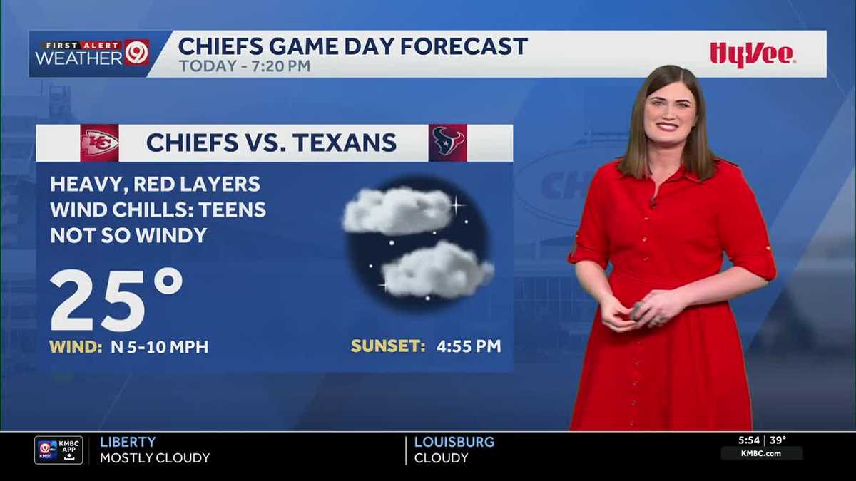
I’M TAYLOR KAUFFMAN KMBC NINE NEWS, THANK YOU VERY MUCH. TAYLOR. WE’VE GOT A BIT OF A RIVALRY HERE. I WENT TO MISSOURI BRITTANY A KANSAS FAN. WE DON’T REALLY KNOW WHAT TO DO. WE DON’T REALLY TALK TO EACH OTHER AT ALL. NO, I DON’T EITHER. THIS IS THIS IS ALL FOR SHOW. I’M GONNA STAY OVER ON THIS SIDE. EXACTLY. STAY FAR AWAY. FAR AWAY? YEAH. I MEAN, WE HAVE THAT GOING ON. WE ALSO HAVE THE CHIEFS GAME. SO MANY THINGS TAKING PLACE AND YOU’RE GOING TO NOTICE IT’S GOING TO BE ON THE COLDER SIDE FOR TODAY. OUR 40S WE SAW THE LAST FEW DAYS ARE GONE COLD START AS WELL FOR MONDAY. YOU’LL NOTICE THAT TOMORROW MORNING. SO OVERALL A LOT OF COLD TO TALK ABOUT. BUT WE DO HAVE ONE WARM DAY. IT WILL BE WARM AND BREEZY ON TUESDAY. HIGHS IN THE 50S BUT IT’S SHORT LIVED. AFTER THAT WE START TO SEE TEMPERATURES FALLING RIGHT BACK DOWN, HIGHS IN THE 20S AND 30S INTO NEXT WEEKEND, SO A LOT TO BREAK DOWN. BUT LET’S START OFF WITH YOUR SUNDAY FORECAST TODAY. TEMPERATURE WISE, A LITTLE BIT OF A WEIRD TEMPERATURE PATTERN. WE’RE ACTUALLY REALLY STARTING TO COOL DOWN A BIT. NOT THAT BAD. MANY OF US AROUND THE MID 30S, WE ALREADY SAW OUR HIGH. THAT WAS REALLY RIGHT AFTER MIDNIGHT. SO WE’RE GOING TO FALL A LITTLE BIT UNTIL ABOUT EIGHT 9:00. WE’LL GET TO THOSE UPPER 20S. AND THEN AFTER THAT WE SLOWLY WARM UP A BIT INTO THE AFTERNOON. BUT MANY OF US WILL STAY BELOW FREEZING TODAY. I’M THINKING OUR HIGH IN KANSAS CITY OR THE HIGH LATER TODAY, WHEN WE NORMALLY WOULD SEE IT WOULD BE 32 DEGREES. FEELS LIKE TEMPERATURES IN THE TEENS AND 20S THROUGHOUT THE DAY. MOSTLY CLOUDY SKIES. NOW, THE GOOD NEWS IS THAT WIND THAT WE HAVE THIS MORNING, GUSTS AROUND 20 TO 30MPH. THAT’S GOING TO RELAX THE SECOND HALF OF THE DAY. SO AS WE HEAD INTO LUNCHTIME, NOTICE HOW THESE NUMBERS ARE DROPPING. THESE ARE YOUR WIND GUSTS AS WE HEAD INTO ABOUT THE EVENING RIGHT AROUND THE START OF THE CHIEFS GAME, 7:00 HOUR WIND GUSTS ARE ONLY REALLY ABOUT LESS THAN 15MPH. SO WITH THAT WIND RELAXING, THAT WILL MAKE IT FEEL NOT AS COLD WHEN IT COMES TO OUR WIND CHILL. BUT I MEAN, IT’S STILL GOING TO FEEL LIKE THE TEENS DURING THIS CHIEFS GAME. AGAIN, THAT SEVEN 20 HOUR TEMPERATURE AROUND THEN 25 DEGREES. MOSTLY CLOUDY SKIES, WIND CHILLS IN THE TEENS, HEAVY RED LAYERS. IF YOU PLAN ON ATTENDING THAT GAME. AND AS WE LOOK AT THE NINE DAY FORECAST, YOU CAN IMMEDIATELY SEE OUR BEAUTIFUL DAY ON TUESDAY. BUT WE HAVE TO GET THROUGH OUR COLD MORNING MONDAY AND THEN THE SECOND HALF OF MONDAY. THAT’S WHEN WE’LL START TO WARM UP A BIT. A LOW TEMPERATURE TOMORROW MORNING, 17 DEGREES, BUT FEELS LIKE TEMPERATURES IN THE LOW TEENS EVEN FOR SOME OF YOU IN NORTHERN MISSOURI RIGHT AROUND THE SINGLE DIGITS. SO WE WILL START OFF COLD FOR MONDAY AND EVENTUALLY TEMPERATURES WARMING UP A BIT, A HIGH OF 40 FOR THE START OF THE WEEK, 54 DEGREES TUESDAY. BREEZY. OUR WIND IS OUT OF THE SOUTH, SO THAT’S GOING TO FEED THAT WARM AIR INTO THE AREA. AND THEN A COLD FRONT MOVES THROUGH WEDNESDAY OUT OF THE NORTHWEST. OUR WIND RETURNS, DROPPING TEMPERATURES 43 AND BREEZY WEDNESDAY. CHANCE FOR SOME FLURRIES ON THURSDAY, BUT WE ARE NOT EXPECTING REALLY ANY IMPACTS WITH THAT. AND THEN AFTER THAT HEADING INTO NEXT WEEKEND. DRY. BUT TEMPERATURES IN THE 20S AND 30S. SO COOLING ON DOWN SOME ARCTIC AIR ON THE WAY AS WE LOO
Much colder end to to the weekend in KC
Breezy start to the day then the wind gradually relaxes. Temperatures struggle to warm to the low 30s with mostly cloudy skies.

Sunday is off to a breezy and cold start! Our wind is now out of the northwest with gusts around 25 mph. This is feeding much colder air into KC and will prevent us from warming up much today. Temperatures drop into the 20s briefly this morning then we gradually warm into the low 30s this afternoon and evening with mostly cloudy skies. Bundle up for the Chiefs game because it will be in the mid-20s by kickoff time with wind chills in the teens throughout the game. Temperatures drop even more overnight into Monday, and we kick off the work week in the upper teens with wind chills in the low teens. Sunshine returns for Monday, and the second half of the day looks warmer in the low 40s. Our warmest day continues to be Tuesday with highs in the mid-50s! But the warmth is short-lived, because a cold front drops temperatures back into the 20-30s for the remainder of the week. Looks like a pretty dry week, but we could see snow flurries on Thursday.
Sunday is off to a breezy and cold start! Our wind is now out of the northwest with gusts around 25 mph. This is feeding much colder air into KC and will prevent us from warming up much today. Temperatures drop into the 20s briefly this morning then we gradually warm into the low 30s this afternoon and evening with mostly cloudy skies. Bundle up for the Chiefs game because it will be in the mid-20s by kickoff time with wind chills in the teens throughout the game. Temperatures drop even more overnight into Monday, and we kick off the work week in the upper teens with wind chills in the low teens. Sunshine returns for Monday, and the second half of the day looks warmer in the low 40s. Our warmest day continues to be Tuesday with highs in the mid-50s! But the warmth is short-lived, because a cold front drops temperatures back into the 20-30s for the remainder of the week. Looks like a pretty dry week, but we could see snow flurries on Thursday.
Leave a Reply